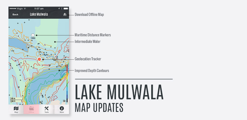
A major upgrade of Lake Mulwala has been uploaded:
- All creeks, lagoons & waterways that were displayed as a blue line only and hard to see on the screen have been filled as intermediate water, the map now displays Deep Water (River course etc – Dark Blue), Intermediate Water (Creeks, Lagoons & Washaways – Aqua) and Shallow Water (Light Blue) and is a major improvement for identifying the area you want to fish or travel through.
- Maritime Distance Markers have been added from upstream of Bundalong through to the Wall.
- The depth contours have been completely overhauled to delete those annoying “tails” that appear on the end of contours and give an incorrect depth reading outside the boundaries of the deeper water. Depth contours are now more meaningful.
What do you need to do:
We highly recommend the use of the iPhone App Offline Maps for a massive increase in response speed. We also recommend the use of the Geolocation Button, turning this feature on keeps your position centre of screen at all times (position Dot turns from blue to ORANGE when activated.)
This Mulwala map upgrade is automatically updated in ONLine Maps, however OFFLine Maps need to be replaced. This is done by selecting Lake Mulwala > Offline, and pushing the download button at top right of screen. It is recommended that this is done whilst connected to WiFi.
Note: If you subscribed to Charted Waters in the last month or so make sure you update your iPhone App (App Store > Updates > Charted Waters) to improve your user experience.