This update affects ALL LAKE MULWALA Maps and ALL maps on ELITE units
[blockquote author="CJ Wilson"]This new version is so much easier to use. It’s like a whole new map
[/blockquote]
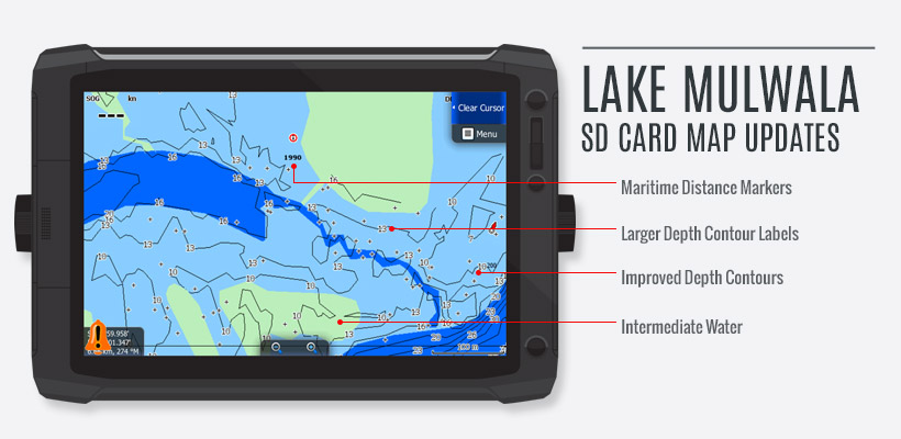
LAKE MULWALA updates (All Sounders) include:
- All creeks, lagoons & waterways that were displayed as a blue line only and hard to see on the unit have been filled as intermediate water, the map now displays Deep Water (River course etc – Dark Blue), Intermediate Water (Creeks, Lagoons & Washaways – Aqua) and Shallow Water (Light Blue) and is a major improvement for identifying the area you want to fish or travel through.
- Maritime Distance Markers have been added from upstream of Bundalong through to the Wall.
- The depth contours have been completely overhauled to delete those annoying “tails” that appear on the end of contours and give an incorrect depth reading outside the boundaries of the deeper water. Depth contours are now more meaningful.
- The font has been increased on the depth contour labels for easier viewing.
This is a major rewrite of the map and the end result is a massive improvement over version 1.
ELITE UNIT fixes (All Maps):
- The issue with the Shaded Relief view disappearing from the screen at a zoom level of 60 metres (200 feet) has been rectified and now displays at 5 metres.
- In the HDI units the colour used to depict deep water appeared purple on the screen, this has been fixed.
What do you need to do:
All card updates are FREE.
Please return your card with a stamped, self addressed envelope and details of your sounder model to:
Charted Waters
PO Box 983
WODONGA VIC 3689