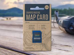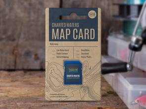
Mallacoota Inlet Map Card
VIC


Mallacoota Inlet Map Card
$88.00
Mallacoota Inlet hosts a diverse range of fish species, but it’s best known for bream and flathead
-
Map Overview
Description
The Mallacoota Map card contains map data for viewing on Lowrance, Simrad and B&G sounders.
This map data includes:- Satellite Imagery
- Depth Contours
- Shaded Relief
- Markers & Structures
- Access Points, Islands
- Shallow Water
- Intermediate Water
- Deep Water
Please see our Sounder compatibility chart for more information.
All maps and charts are for reference purposes only. Not for navigation. This map uses Department of Environment, Land, Water and Planning data, OpenStreetMap & Google Earth Image © 2015 Digital Globe.